
|
Interactive map of Khanty-Mansiyskiy Avtonomnyy Okrug - Yugra
|
| History In December 10, 1930 there was founded Ostyako-Vogul'skiy National Okrug which was renamed in 1940 into Khanty-Mansiyskiy National Okrug. Since 1978 the region was called Khanty-Mansiyskiy Avtonomnyy Okrug and only in 2003 it got its present name.
Since 1930 up to 1934 it was a part of Ural'skaya oblast', in 1934 it was included in Obsko-Irtyshskaya Oblast', since 1934 till 1944 the region was a part of Omskaya Oblast' and only since 1944 it was became a part Tyumenskaya Oblast'. |
|
Geography
Khanty-Mansiyskiy Avtonomnyy Okug-Yugra is a subject of the Russian Federation (part of Tyumenskaya Oblast'). It makes a part of Ural'skiy Federal Okrug.
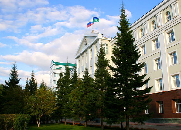
The administrative centre is Khanty-Mansiysk. The Okrug borders with: Yamalo-Nenetskiy Avtonomnyy Okrug, Krasnoyarskiy Kray, the south of Tyumenskaya Oblast', Tomskaya and Sverdlovskaya Oblast' and the Komi Republic. Khanty-Mansiyskiy Avtonomnyy Okrug occupies the central part of Zapadno-Sibirskaya Ravnina (West Siberian Plain) and has an east-west extend of 1,400 km (0.87 mi Int.) - from the Ural mountain range to the Ob-Enisey watershed. It has a north-south extend of approximately 800 km (0.5 mi Int.) being spaced in between 58º30’ and 65º30’N. The Okrug borders' length makes 4,750 km (2,95 mi Int.). Its territory is a vast plain slightly divided by absolute altitude marks that rarely reach 200 m above the sea. Population The Okrug is populated with 1,520 thousand people (2009) (1,505.2 thousand in the year 2008), the population density is 2.8/km2 (2009), urban population density is 91.5% (2009). The average monthly income per capita in March, 2009 made RUR 27,968.3, and the Okrug average monthly earnings reached RUR 40,362.5. Climate
The Okrug has a temperate continental climate characterized by a rapid weather change, especially during autumn and spring seasons, as well as during a twenty-four hours' day. The climate is mainly formed by the Ural mountain range protecting the Okrug from the West and no any shelter to protect the territory from the North making it easy for the cold Arctic air mass to host in the area. Winter seasons are long and severe with steady snow cover; summer seasons are short and relatively warm. Annual precipitation is 400-620 mm.
The snow depth varies from 50 to 80 cm. Maximum precipitation occurs in summer seasons. Taking into account relatively little precipitation amount, the evaporation is not that significant, so the territory is located in the excessively humid zone. The mid-seasons are characteristic of late spring and early autumn wind chills. The Okrug average temperature for January varies from -18ºC (-0.4 F) to -24ºC (-11.2 F). The lowest temperature level (60º – 62ºC (76 F – 79.6 F) below zero) was recorded in the Vakh River valley in Nizhnevartovskiy Rayon. The average temperature for the warmest month of July varies from 15.0ºC (59 F) (in the north-west) to 18.4ºC (65 F) (in the south-east). The maximum temperature recorded is 36ºC (96.8 F). The annual length of sun shining in the Okrug makes 1,600 - 1,900 hours, and in the City of Khanty-Mansiysk - 1,765 hours (compared to the Cities of Sankt-Peterburg - 1,563 hours, Kursk - 1,775 hours, Kyyiv - 1,843 hours).  |
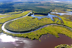
Hydrography The principal rivers are the Ob' River and its tributary - the Irtysh River. The other significant rivers are the Ob' tributaries: Vakh, Agan, Tromegan, Bol'shoy Yugan, Lyamin, Pim, Bol'shoy Salym, Nazym, Severnaya Sos'va, Kazym, and the tributaries of the Irtysh River: Konda and Sogom.
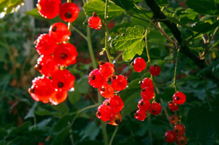
 Flora Flora of the Khanty-Mansiyskiy Avtonomnyy Okrug numbers more than 800 species of higher plants. Practically all the Okrug territory is located within one natural zone, the taiga forests, and only in the outer north-west Urals region it extends into the forest-tundra and alpine tundra zones. The major part of the territory is a vast stretch of wetland taiga. The Okrug vegetation is represented by communities of mixed-wood and coniferous forests, swamps, flood meadows, water bodies, alpine tundras. The woodlands cover about 52 per cent of the territory. A considerable part of it is occupied by the middle taiga zone with dark coniferous and light coniferous forests, as well as mixed-wood forests and forests of small-leaved deciduous species. They are composed of spruce (Picea abies), cedar, fir (Abies Sibirica), pine (Pinus Sibirica), larch (Larix sp.), birch (Bertula tortuosa), alder (Alnus Mill). Floodplains and flatlands are characterized by meadow vegetation. High floodplains of large rivers are often covered with park-like willow-stands and mixed forests of willow and birch trees, willow, birch and aspen (Populus tremula) trees with grass layers. Forests and swamps are rich with berries, which are: cranberry (Vaccinium oxycoccus), cowberry (Vaccinium vitis-idaea), bilberry (Vaccinium myrtillus), bog bilberry (Vaccinium uliginosum), currant (Ribes), cloudberry (Rubus chamaemorus), raspberry (Rubus idaeus), dog-rose (Rosa canina), bird cherry (Prunus padus), European rowan (Sorbus aucuparia). Native peoples traditionally use about 200 plant species for their medical purposes.
 Fauna
Wild animals are typical for the Russian taiga. Vertebrate fauna numbers 369 species. Mammals account 60 species, 28 of which are game animals. The most widespread and valuable ones for the economy are the following: fox (Vulpes vulpes), Arctic fox (Vulpes lagopus), squirrel (Sciuridae), sable (Martes zibellina), marten (Martes), short-tailed weasel (Mustela erminea), Siberian striped weasel (Mustela sibirica), forest polecat (Mustela putorius), Russian mink (Mustela lutreola), otter (Lutrinae), hare (Lepus), wild reindeer (Rangifer tarandus), Eurasian elk (Alces alces) and others. Wolverine (Gulo g.) and West Siberian beaver (Castor fiber pohlei) have been registered into the Russian Red Data Book.
The Okrug avifauna is represented by 256 bird species, including 206 species of non-migratory and nesting birds. Game birds are basically geese (Anser), grouse (Tetraoninae), black grouse (Tetrao tetrix), hazel grouse (Tetrao bonasia), partridges (Perdicinae), ducks (Anatidae), sandpipers (Scolopacidae). The most noted birds of prey are neophrons (Accipitridae), marsh harriers (Circus aeuginosus), long-eared owls (Asio otus). One can find some rare species listed on the Red Data Book: Dalmatitian pelican (Pelicanus crispus), black stork (Ciconia nigra), flamingo (Phoenicopterus), lesser white-fronted goose (Anser arythropus), golden eagle (Aquila chrysaetos), peregrine (Falco peregrinus), hooded crane (Grus monacha), Siberian white crane (Grus leucogeranus), clender-billed curlew (Numenius tenuirostris), white-tailed eagle (Haliaeetus albicilla), osprey (Pandion haliaetus), gyrfalcon (Falco rusticolus), brant goose (Branta bernicla), red-breasted goose (Branta ruficollis). Rivers and lakes are inhabited by 42 fish species. Only 19 species are commercial fish. These are sterlet (Acipenser ruthenus), nelma (Stenodus leucichthys), muksun (Coregonus muksun), peled/syrok (Coregonus peled), broad whitefish (Coregonus nasus), Siberian whiefish (Coregonus lavaretus pidschian), tugun (Coregonus tugun), burbot (Lota lota), pike (Esox lucius), ide (Leciscus idus), roach (Rutilus rutilus), bream (Abramis brama), dace (Leuciscus leuciscus), perch (Perca), ruffe (Gymnocephalus cernuus), crucian carp (Carassius carassuis), Prussian carp (Carassius gibelio). Carps (Cyprinus carpio) are also reared in heat sinks of Surgutskaya and Nizhnevartovskaya GRES (State Regional Electric Power Plants). The Okrug is famous for the sturgeon (Acipenseridae) which is registered in the Red Data Book. Unfortunately, it is also known for the abundance of mosquitoes and gnats. A large amount of blood-sucking insects is a serious trouble for domestic animals and people working in the open-air. So, the average number of adult mosquitoes per a square meter of the forest land of the Ob' River and its tributaries is 4 to 12 insects. |
Natural Resources
The Okrug has an impressive natural resources potential. First of all, these are oil and gas reserves, forest and deposits of a number of solid minerals. There were discovered more than 400 oil and gas-and-oil fields with the reserves of about 20 bln tons of the resources. The expected oil reserves make 35 bln tons. The largest oil fields are those of Samotlorskoye (one of the ten largest oilfields in the world), Fedorovskoye, Mamontovskoye and Priobskoye. As a rule, oilfields are rich with the associated gas which is the most valuable upstream material for the chemical industry. Sadly enough but gas is mostly burnt at the fields, only the small amount of it is used as fuel at the largest thermal power plants (Surgutskaya GRES-1 and Surgutskaya GRES-2). In the amount of associate gas reserves in the Russian Federation Khanty-Mansiyskiy Avtonomnyy Okrug takes the second place after Yamalo-Nenetskiy Avtonomnyy Okrug.
Besides oil-and-gas deposits, the Okrug is rich in hard-rock gold and placer gold, which possible reserves are estimated to be 220 tons of ore material formation. The geological works on the territory of the Okrug, bordering the Ural Mountains, showed the deposits of ore, as well as flows in bauxite, copper, zinc, lead, niobium, tantalum, etc. Deposits of vein quartz, rock crystal and piezo quartz are being commercially developed. The quality of the above mentioned materials is one of the best in the world. On the territory of the Okrug there were discovered the deposits of straight and anthracite coal which reserves are estimated in 4,600 tons and 970 mln tons accordingly. The Okrug also has deposits of trim stone, brick-and-keramzite clay, mortar sand, as-dug gravel, innumerable peat deposits, and the valuable material for agrochemical industry - decay ooze. There are huge resources of fresh, mineral and thermal underground waters which have been harnessed insignificantly so far.
 |
The Emblem of the Khanty-Mansiyskiy Avtonomnyy Okrug - Yugra is a silver emblem placed on the lining of two shields, inserted one into another, and representing stylized emblem "Kat ukhup voi" (double-headed bird) in the field of divided azure (blue, light blue) and green shield. Contour of the shield is marked with gold. Figured shield is inserted into the red rectangle shield with figured bevel on the bottom. Shield is crowned with white element designed in Ob-Ugric people's style, framed with cedar green branches interlaced in a semiring. Motto "Ugra" is written in silver letters on the azure lace placed under the shield. The Flag of the Khanty-Mansiyskiy Avtonomnyy Okrug - Yugra is a rectangular cloth divided horizontally into to stripes (light blue top stripe, green bottom stripe) framed vertically with rectangular white stripe. In the left part of the cloth there is a white element from the emblem of the Khanty-Mansiyskiy Autonomnyy Okrug - Yugra. Nizhnevartovsk is the City of Okrug significance (since 1972) located on the right bank of the Ob' river, in its middle reach, 800 km (0.5 mi Int.) away from the City of Tyumen and 400 km (0.25 mi Int.) away from the City of Khanty-Mansiysk. The city's area is 26,421 ha. Its population numbers 248,300 people. The city began developing in the early 1960s with the discovery and development of the oil fields in KhMAO. The largest deposit Samotlorskoye is the largest oil field in Russia and is located in the Nizhnevartovskiy Rayon. That is why Nizhnevartovsk is called the oil capital of Russia. |